


Field Monitoring Conducted to Digitalize Hydrological Control
A joint Turkmen–Kazakh team of hydrological accounting and rescue specialists inspected the operation of the cross-border early warning system near the Kerki hydropost on the Amu Darya, close to the villages of Dashrabat and Boreshl. They identified locations for GIS studies planned for 2026, as well as opportunities for preparing proposals to improve the regional hydrological early warning system in Central Asia. The information was reported on the official website of Turkmenistan’s Ministry of Environmental Protection.
The report notes that the work was carried out in close cooperation with the specialists of the hydrometeorological service of the Ministry of Environmental Protection of Turkmenistan and the civil defense and rescue units of the Ministry of Defense.
Experts from the Center for Emergency Situations and Disaster Risk Reduction in Almaty (Kazakhstan) — A.K. Akparov, A.G. Ospanov and V.V. Kuchkin — also took part. This cooperation has been ongoing since last year and is based on a joint GIZ project: “Strengthening Safe Transboundary Water Management in Central Asia through Innovative ICT Solutions,” which is part of the GIZ regional program “Climate Risk Management in Central Asia.”
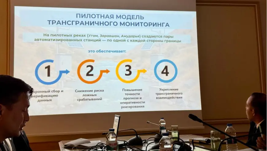
Before field deployment, consultations with Turkmen hydrometeorologists were held at the “Turkmengidromet” headquarters in Ashgabat. It was noted that pilot field studies are currently underway in cross-border river basins: in 2024, research was conducted in Kazakhstan and Uzbekistan — on the Ugham and Zarafshan rivers; earlier this year it continued in Tajikistan on the Zarafshan, and since October has begun in Turkmenistan and Kyrgyzstan.
Upon arrival in the Kerki district of Lebap Province, the joint Turkmen–Kazakh expedition team, together with local authorities, discussed organizational and technical matters — particularly opportunities to modernize the hydrological monitoring system and local early warning mechanisms. Specific zones for pilot hydrological studies from next year to 2028 were identified.
In general, it is planned to install automated monitoring stations equipped with modern computer systems and satellite Internet on existing hydrological posts in Central Asian countries — including Turkmenistan. Effective public warning tools — siren-based alert systems and special mobile applications — will also be introduced.
Interactive atlases integrated with the automated stations will be developed to ensure timely, real-time data. As the specialists noted, the aim of the mission is to identify potential hydrological risks and reflect them in the interstate early warning system along with appropriate preventive measures.